The Story of the Wartime Kokoda Trail: Sorting Fact from Fiction
Part Two: Peter Jesser
This article continues from the excerpt published in PNG Kundu, June 2024.
The Way North from Port Moresby
One of the reasons that there had never been a track across the mountains from Port Moresby was that the local people on the north side of the Owen Stanley Range (the Orokaiva) and those on the south side (the Mountain Koiari) were both hostile to outsiders. The intervening mountains from Alola on the north side to the Koiari village of Kagi in the south were, as pointed out in Bert Kienzle’s biography ‘… a no-man’s-land, a place of darkness the Papuans called vabula. This was a buffer zone between two different tribal areas where, by native custom, any stray trespasser was fair game.’[12] There was every reason for the Papuans not to cross the mountains.[13]
But European world views and needs differed from those of the Papuans and, by the late 1890s, miners on the Yodda goldfields were agitating for the government to establish a more convenient ‘road’[14] across the mountains. This would enable an overland mail service to be established—something which would improve service times and decrease reliance on irregular shipping. It would facilitate the government maintaining a presence in the interior to help in pacifying the local people.
With this end in view, on 25 April 1899, two government expeditions set out from Port Moresby heading towards the Owen Stanley Range (or Main Range). The first, led by Mr D Ballantyne, set out with the aim of contacting the Hagari tribe in the hills towards the Main Range and convincing them to allow government patrols to traverse their country. In this aim, Ballantyne succeeded.[15]
On the same day that Ballantyne set out, a second expedition, led by Mr HH Stuart-Russell (the Government Surveyor) left Port Moresby. According to the Government Report for that year:
The objects of the expedition were to examine the country between the coast and the Gap to the bottom of the Main Range, for the purpose, if possible, of discovering a track that would be suitable for a road over the range. The Gap is the name given to a marked depression in the Main Range, situated to the south-eastward of Mount Victoria.[16]
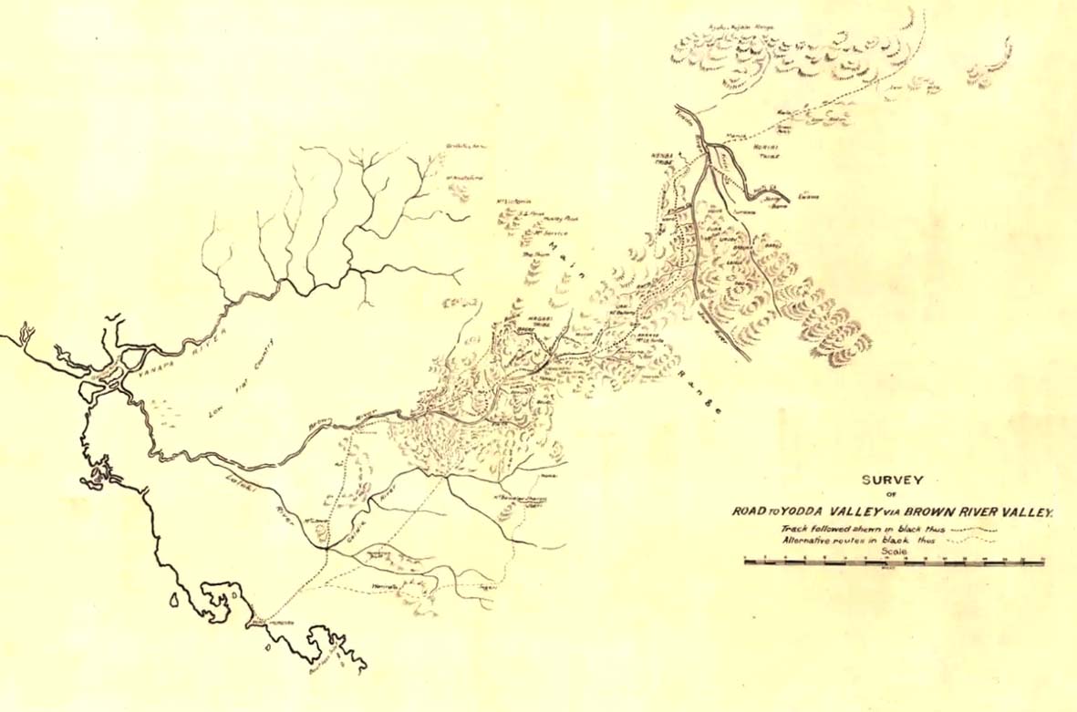
Stuart-Russell travelled up the Brown River and waited until receiving word from Ballantyne that the way was clear to proceed. The expedition continued—with some difficulty— through the Gap and down to the Yodda, achieving its purpose. Stuart-Russell’s map of the route taken—‘Survey of Road to Yodda Valley via Brown River Valley’[17]—was appended to the ‘Annual Report on British New Guinea from 1 July 1898 to 30 June 1899’. In his report on the journey, Stuart-Russell observed that on the north side of the range they met with hostile tribes who pursued them part of the way back to the Gap. He concluded:
The mountainous nature of the country travelled through prevented a definite conclusion being formed as to whether the route followed was the best one for a future road. The formation of the country at the Gap itself hardly seemed suitable for a road, at least for pack animals. So far as could be judged, a good track could be got from the point where the party struck the Yoda [Yodda River] to Tamata Station, on the Mambare. But the country through which such track would pass is inhabited by natives that have not yet been brought under the influence of the Government.[18]
Stuart-Russell took three months to complete his expedition, on which he extended his orders and pressed on to the Yodda. His party was running short of supplies and hard-pressed by hostile ‘natives’ when another Government Officer, C.A.W. (Charles) Monckton was despatched with relief supplies. Monckton aided Stuart-Russell’s return. But although the Annual Report for the year praised Stuart-Russell’s work, Monckton had a different take on the crossing. According to Monckton, Stuart-Russell had exceeded his orders in pressing on to the Yodda.
This was acknowledged in a letter to Stuart-Russell from the then Administrator, Sir George Le Hunte, which began: ‘You dear disobedient person, I should be very angry with you, but instead, I can only feel pleased.’[19] Stuart-Russell had blazed a track across the mountains.
His diagrammatic map showed the route he had taken, rivers and streams, and a hachured representation of the terrain giving a rough indication of contours.
The Yodda Valley Road
With this groundwork completed, in 1904, the route for a proposed mail service between Port Moresby and the northern goldfields was set down. Kokoda Station—roughly the halfway point—was established by Monckton and set up as the other end of the mail run from Port Moresby. Monckton later referred to the ‘big Yodda Valley road’ traversing his area of responsibility. A fortnightly mail service was implemented. It is mainly for this that the original track to Kokoda is remembered. Members of the Royal Papuan Constabulary (RPC)—usually travelling in pairs—would journey between Port Moresby and Kokoda Station on a regular basis, carrying official mail between the two locations. They would wait at their destination for two or three days to collect return mail which they then carried back.
There were a few subsequent crossings by government officers, but the last record seems to have been that of Resident Magistrate WR (Dickie) Humphries who made the crossing in 1923. In the early years, others also used the track. In 1908, Seventh-Day Adventist missionaries established a base at Bisiatabu, near Sogeri. According to Nelson, in 1913 Pastor Septimus Carr walked to Kokoda, and in 1924 Pastor William Lock and his family, including their young son Lester Lock, walked from Bisiatabu to Efogi, partway along the track. The Lock family stayed at Efogi for the next two years, developing a church.
In 1940, after Lester Lock had completed theological training in Australia, he returned to Papua where he was appointed to Bisiatabu. From there, in 1941, he traversed the southern end of the track to Efogi on church business. However, in his book, which covers his time in Papua, Lock does not suggest that he ever went further than Efogi.
The Territory’s Administrator, Sir Hubert Murray, apparently walked the track more than once but, with the establishment of an airstrip at Kokoda in 1932, Murray remarked that he probably would not be making the trek on foot again. No historian appears to have identified any other records of government officers or other Europeans making the crossing after 1932. The RPC mail service also became more sporadic as the 1930s progressed. There was no regular air service, but air delivery on an opportunity basis reduced the need for the overland service.
By the 1930s, only the Papuan mail carriers of the RPC retained first-hand knowledge of the track.
Notes
- Kienzle, Robyn, The Architect of Kokoda, Hachette: Sydney (2011), p. 118.
13.Nevertheless, it seems that occasional crossings had been made in the past, possibly on head-hunting raids. The crossing was alleged to have taken ‘five sleeps’—roughly the same time that it would take Lieutenant Harold Jesser’s party to cross in January–February 1942.
- A ‘road’ in this era was simply a conveniently cleared walking track. It was not until the advent of motor vehicles in later years that it assumed the specific meaning of a vehicular road.
- ‘Annual Report on British New Guinea from 1st July 1898 to 30th June 1899; with Appendices’, Brisbane: Queensland Government (1900), pp. xv-xvi. (The last two pages of the report, one of which would be the relevant map, are missing from the Report held at the National Archives. A copy of the map, catalogued as ‘Survey of road to Yodda Valley via Brown River Valley / M.I. L.H.Q. August 3 1942’, was located at the National Library of Australia; catalogue.nla.gov.au/Record/8049238 accessed 15 August 2021.
- ‘Annual Report on British New Guinea’, p. xvi.
- Survey of road to Yodda Valley via Brown River Valley’ Ibid.
- ‘Annual Report on British New Guinea’, p. xvi.
- Monckton, C.A.W, Experiences of a New Guinea Resident Magistrate, Newnes: London (c. 1922), p. 289.
Editor’s Note:
This article is an excerpt from the PIB NGIB HQ PIR Association website and can be read in full at https://www.soldierspng.com/?page_id=5390. It is reproduced
in the PNG Kundu with the author’s permission.

HH Stuart-Russell map ‘Survey of Road to Yodda Valley via Brown River Valley’, appended to the ‘Annual Report on British New Guinea from 1 July 1898 to 30 June 1899’. Map copy dated 3 August 1942 marked ‘TRACED IN IA SECTION M.I. L.H.Q. FROM A PRINT DATED 16.6.42’ (National Library of Australia (nla.gov.au), catalogue.nla.gov.au/Record/8049238).


